This extremely senic and historic trail is one of the better known areas in the central portion
of the southern Cherokee National Forest. It is currently undergoing a complete renovation. When
it was scouted, extensive trail maintenance was underway which is hopefully completed by now.
The challange here is in finding the trailhead! Once on the trail it is very easy to follow as
one just follows Coker Creek down the mountain from the beautiful Coker Creek Falls to the Hiwassee River. You are not even asked to get your feet wet crossing the creek.
However do not be misled into thinking it is just an easy stroll along a creek bank. It is that for
much of the way, but, like its connector trail, the John Muir Trail beside the Hiwassee, it frequently climbs steeply up and over bluffs along the river bank thereby presenting short but very steep sections
to add a little interest and challenge.
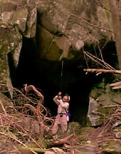
Near the falls is a very large rock house which the scouting party found quite interesting. See the insetpicture of Lin-Fa Lee testing the height of this formation. This type of formation is somewhat unusual in the Cherokee, although quite common across the valley
on the Cumberland escarpment.
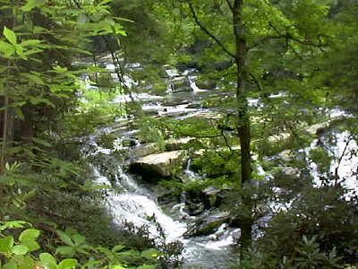
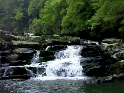 The Coker Creek Falls is really a series of waterfalls which extends a tenth of a mile or more along the
trail. There are four major ledge falls with falls varying from 5 feet to 40 feet in height and 75 feet
or so across.
The Coker Creek Falls is really a series of waterfalls which extends a tenth of a mile or more along the
trail. There are four major ledge falls with falls varying from 5 feet to 40 feet in height and 75 feet
or so across.
To find this trail from Chattanooga, take US64 east thru the Ocoee River Gorge to Ducktown.
At Ducktown take TN68 north toward Tellico Plains.(You may also reach this trail by heading south on SR68
from Tellico Plains)
You will cross the Hiwassee River on SR68 and cross into Monroe County. Just past a bridge over
Coker Creek itself (unmarked!) turn left onto Bailey Road (also unmarked). This road takes you steeply
uphill to FS22(Ducket Ridge Foad) where you will turn left. Shortly thereafter the pavement ends. In about
3 miles you will see a sign on the left for Coker Creek Falls. FS2138 turns left and goes steeply downhill
for one mile to trailhead parking lot. You may want to walk this mile if it has been raining and you
do not have 4-wheel drive! If you miss the turn off SR68 (highly likely) and find yourself in Ironsburg,
turn left just before the Ironsburg United Methodist Church on FS22. At .9 mile take a left fork at a sign
reading Coker Creek Falls. This is at a hilltop with a small cemetery which will be to your left. In another
mile or so, you will come to the intersection with Bailey Road where you will bear right on FS22.
This trail is approximately 2 hours from Chattanooga.